Approaching Gamla from the east you can see the camel-like shape of the mountain from above.
The Golan today is heavily agricultural, covered with farms growing apples and cherries, vineyards full of grapes for wine, and cattle. There are almost as many cattle here as people. While the human population is less than 25,000, the bovine population is more than 20,000. Driving around the plateau, we saw many small herds of cattle. The many waterfalls and pristine countryside make the Golan prime tourist area, but there is a caveat. During the years Syria controlled the land, they planted thousands of land mines. Many of the explosives are still hidden just under the surface. Every year a farmer or two loses an animal because it stepped on a land mine.
The earth is one of the most distinctive features of the area. Having been built up over millennia by volcanic eruptions, the soil and rocks are gray to black in color. Although the area is still subject to relatively frequent earthquakes, no one worries about the volcanoes. The last one ceased being active over 10,000 years ago.
Jewish settlement in the Golan is ancient, dating back to the early Biblical period. When Joshua led the tribes of Israel out of the desert into the land, the tribe of Menashe received the Golan. After King Solomon’s death, when the kingdom split, the Golan naturally became part of the northern kingdom, Israel. King Ahav defeated Ben-Hadad, the King of Damascus near today’s Kibbutz Afik. About five hundred years later, Judah Maccabee helped the local Jews fight their Syrian neighbors. His nephew, Alexander Jannai, one of the last Hasmonean kings, later added the Golan to his kingdom.
The area continued to be a battleground during the Great Revolt against the Romans. The most famous battle was the one for the city of Gamla. The name of the city is related to the word ”gamal,” which means camel. From the mountains above, the area does resemble the profile of a camel. It is an isolated hill top surrounded by deep valleys, connected to the mountain on its eastern side by a narrow land bridge. The mountains that surround the site and the challenging terrain make it a favored hiking destination for younger people. A recently built road from the picnic area to a spot near the archeological site allows people to ride part of the way in a bus. But to get to the city itself, we still had to walk about ten minutes from where the bus stopped.
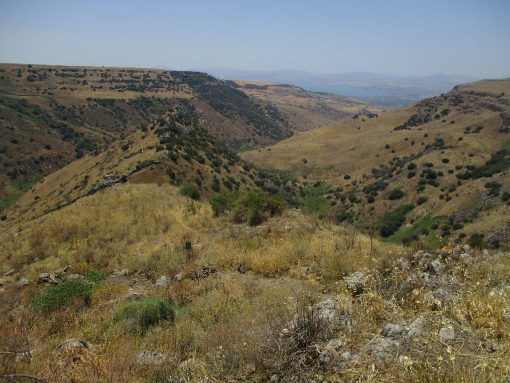
The path winds around the side of a mountain. The drop into the valley on the other side is frighteningly steep. But the view across the valley is breathtaking. In the distance we could see the northern end of the Kinneret and on its far side the mountains of the Galil. We had no idea where the city itself was; we just stayed on the road.
We walked around a bend and saw the city below us, the hill on which it sits nestled among the mountains. From there it was easy to understand its strategic location. One gate across the land bridge could have easily kept enemies out of the city.
It was a sunny day, and by this point on the path we were all hot and tired. The Nature and Parks Authority must have known this would happen; they built a shady shelter at that bend. We sat drinking our water and drinking in the view.
Roman ballista replica, aimed at city of Gamla
Shulie Mishkin, our guide, pointed out landmarks within the city to help us understand what we were seeing. On the lower slope of Gamla we saw a wall that the Romans had breached and the remains of the synagogue. Higher up were remains of houses. Next to the shelter the Parks Authority had placed a replica of a Roman ballista, a weapon used in the assault of the city. When I stood behind the ballista, I could see it was aimed at the synagogue. The stones flung from where I stood would have helped break down the city wall.
Three Roman Legions, about 16,000 soldiers besieged the city for several weeks. The 9,000 Jews within its walls resisted for more than a month.
As we entered the city, Shulie pointed out an opening where the wall had been breached by the Romans. Although this was not a major break in the wall, some of the legionaries had entered the city here. But the Romans had also undermined one of the defensive towers protecting the wall and the city. When that fell, the legionaries poured in. They fought their way across the city, pushing the Jews closer and closer to the cliff on the city’s western edge. Many residents threw themselves off the cliff into the ravine far below, rather than be captured. This mass suicide has led to Gamla’s being called the “Masada of the North.”
Shulie Mishkin points out features of Gamla’ssynagogue
The synagogue faces southwest because Jews have always turned towards Jerusalem in prayer since the day King Solomon dedicated the First Temple. Like other Second Temple period synagogues, it is rectangular, measuring about 52 by 65 feet. The steps on all interior sides would have been used for seating. A mikveh is next to the entrance. Several small rooms and cupboards surround the main room. Their function is unknown today, but many ideas have been proposed. A niche near the door on the southwest side may have held Torah scrolls. Perhaps the room off the western end housed visitors staying overnight in town.
After the destruction of Gamla by the Romans in 68 CE, its location was forgotten. No Jews lived in the Golan until the Byzantine period, about two to three hundred years later. At that time, the northern portion was a pagan center, which then became a heavily Christian area. The Jews stayed primarily in the central and western areas. Around thirty or forty Byzantine era synagogues have been found here. Many of them feature beautiful mosaics, whose style help archaeologists to date the remains.
The large earthquake of 749 CE destroyed most of the communities, as well as Beit Shean in the Jordan River valley. After that, almost no one lived there.
From 1948 to 1967 the Golan was controlled by Syria. They used the beautiful fertile land almost exclusively for military purposes. They built several military and terrorist training bases. Multiple artillery units were stationed in the area, from which they frequently fired at Israeli kibbutzim in the Galil.
After Israel conquered the Golan in the Six Day War, the Israel Antiquities Authority (IAA) sent archeologists to survey the area and locate forgotten Jewish sites. During a lunch break one day, Yitzchaki Gal, a young kibbutznik who was working in the survey team, wandered off from the main group. As he ate his sandwich, he looked at the mountains around and below him. Something looked familiar. As he started to trace the outlines of the hill, he suddenly realized he was seeing what Josephus had described: the camel shaped-hill on which the city of Gamla had stood.
An archeological team was dispatched to explore the site in depth. The more places they dug on the hill, the more closely it matched Josephus’ description of the city. Even more importantly, they found evidence that adds details to his description of the Roman siege and conquest.
Yitzchaki Gal was not the first amateur to discover important relics, nor was he the last. Every year the IAA reports several amazing discoveries made by tourists casually participating in a dig for a week or two or by students hiking through the country. The history of Israel may be very long, but it is still being, literally, uncovered today.
Location of Gamla: